History of Crawford County
Twelve years before Crawford County was partitioned from Allegheny County, David Mead and his nine adventurers arrived in French Creek Valley and camped on the shore of Mill Run. Jonathan Titus made a permanent settlement of Oil Creek four years before the division.
The Legislature on March 12, 1800, passed an act separating Crawford, Mercer, Venango, Warren, and Erie counties from the territory of Allegheny County, which were to form temporarily one county under the name of Crawford. Three trustees were appointed for each county, those for Crawford being David Mead, Frederick Haymaker, and James Gibson. Later Erie, Mercer, Venango, and Warren were organized as separate counties.
COUNTY SEAT, EARLY SCHOOLS, AND COURTS
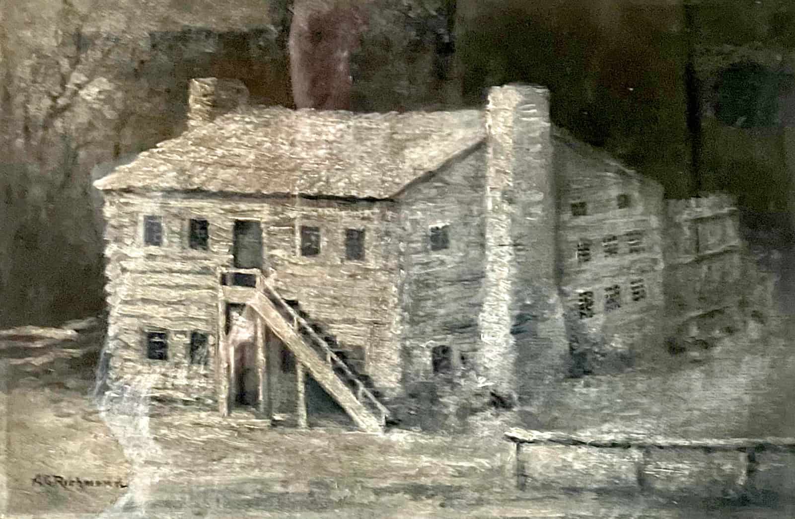
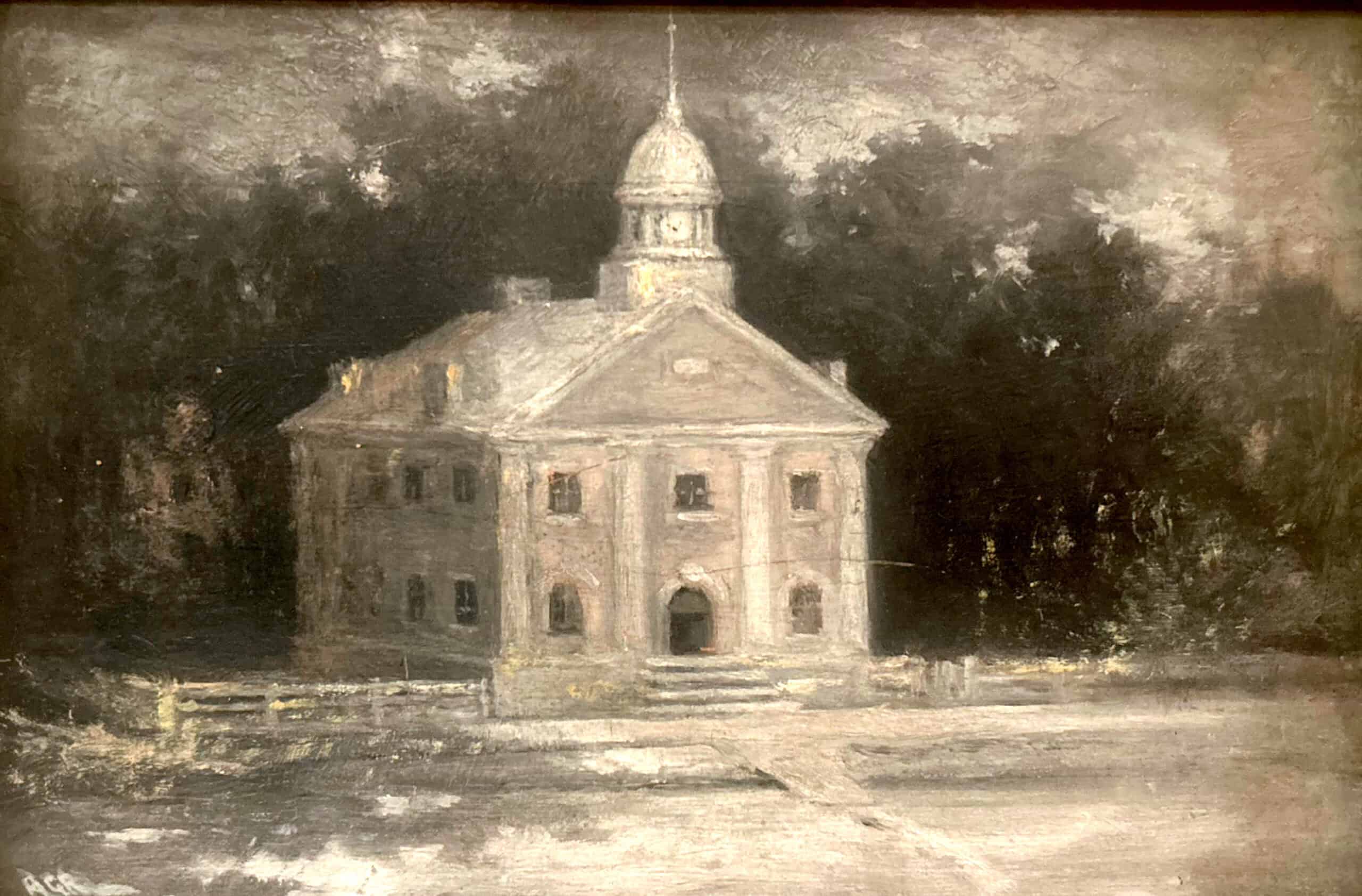
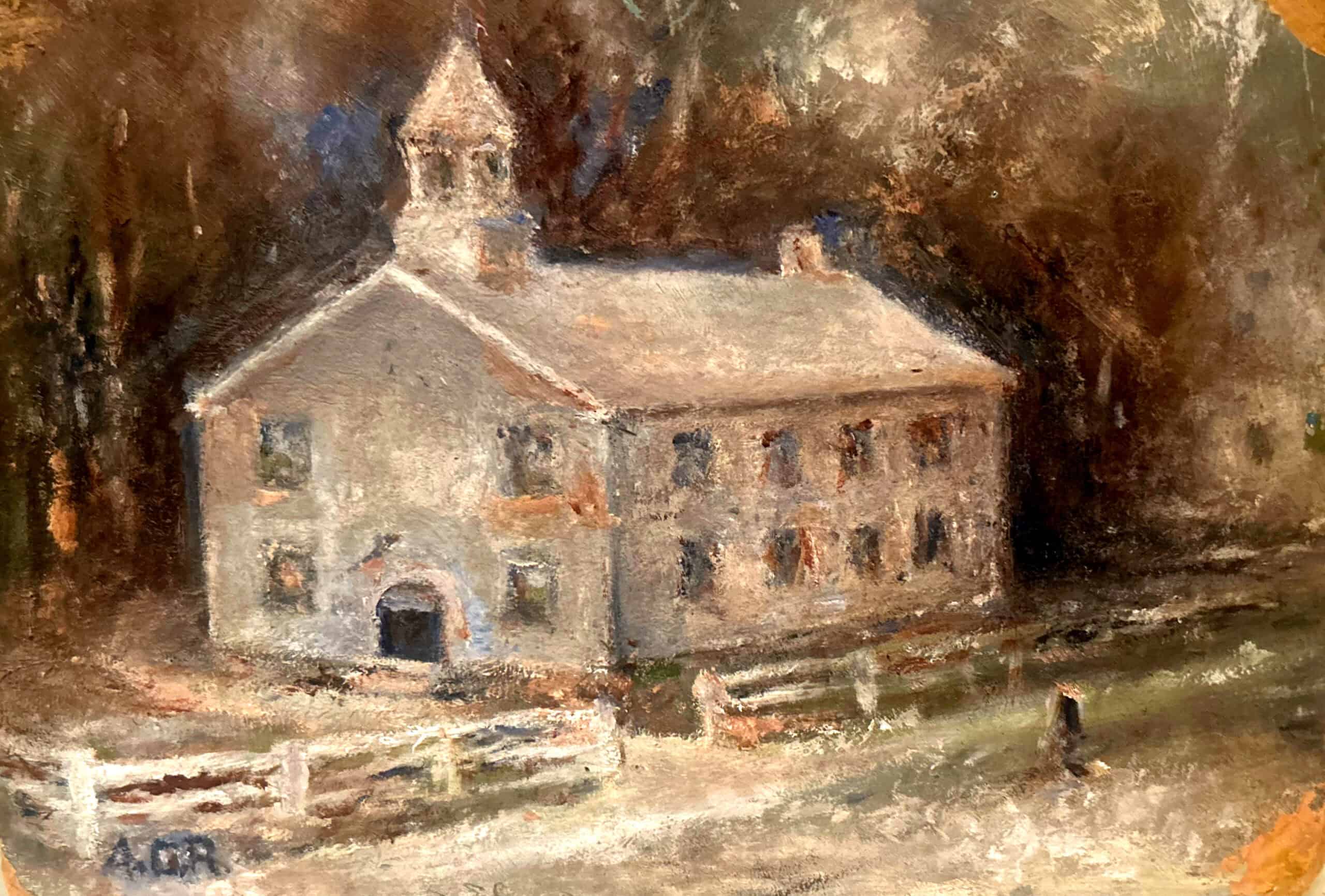
First courthouse building constructed in 1805 by William Dick. Painting by A.G. Richmond. Collection of Allegheny College.
Religion
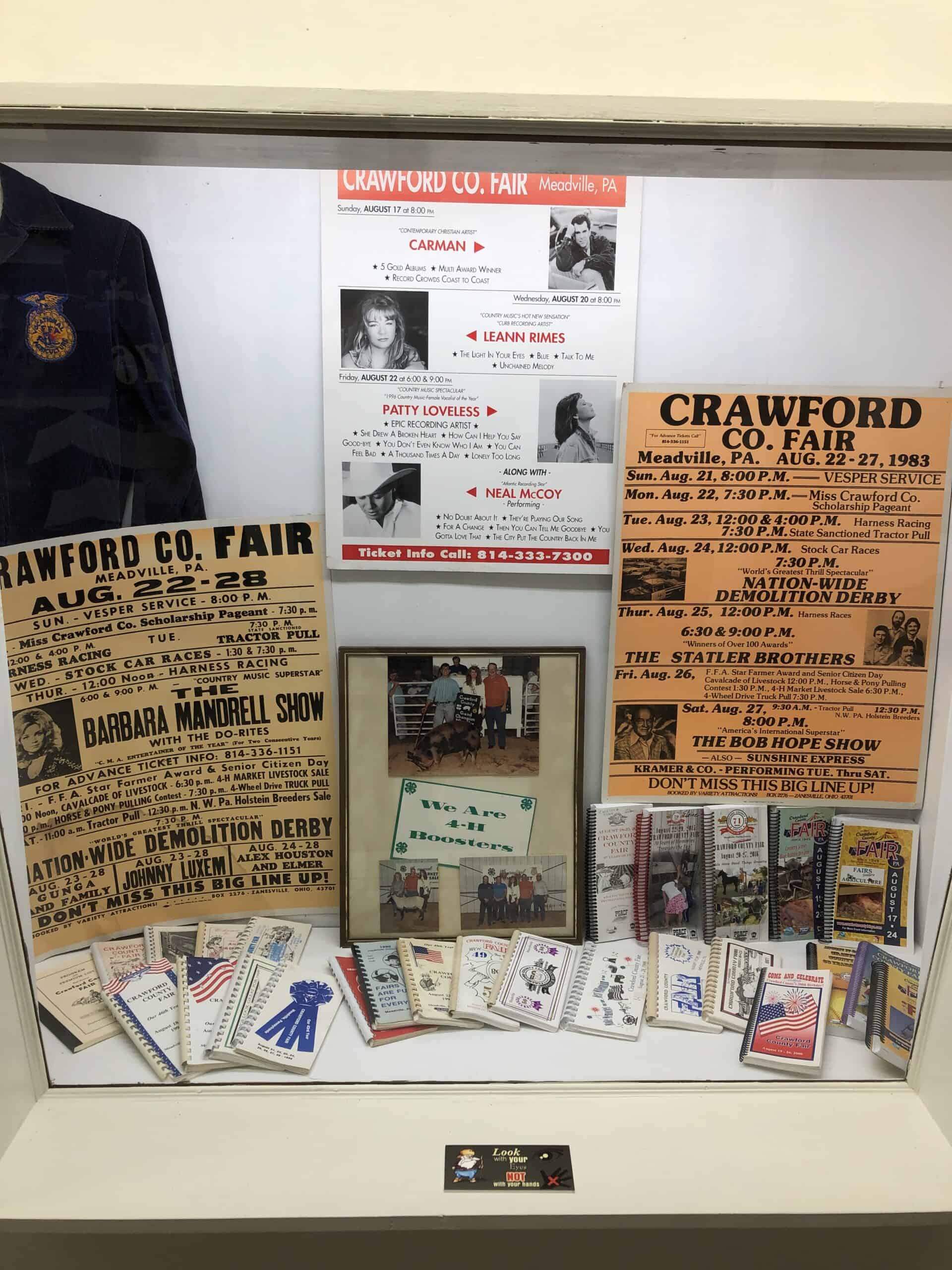
Crawford County’s First Newspaper
One of the things which interested all the people in the west was news of the outside world. Living as a pioneer in northwestern Pennsylvania had many disadvantages. On January 2, 1805, the first issue of the Crawford Weekly Messenger came off the press of T. Atkinson and W. Brendle. There was a group of Meadville citizens on hand to watch the birth of a newspaper -- the fifth newspaper started west of the Allegheny Mountains.
Thomas Atkinson, the editor, was an intelligent and fearless man interested in the welfare of the community and the surrounding country. He held a number of public offices and was eager to lend his active support to any movement for the betterment of the settlement. His paper brought the news of the world to the citizens of Crawford County. He continued to publish his paper for nearly thirty years. A complete file has been preserved which contains valuable information about the conditions which existed during the early times and of the people of those days. For further information, contact the Crawford County Historical Society at (814) 724-6080.
War of 1812 and the Battle of Lake Erie
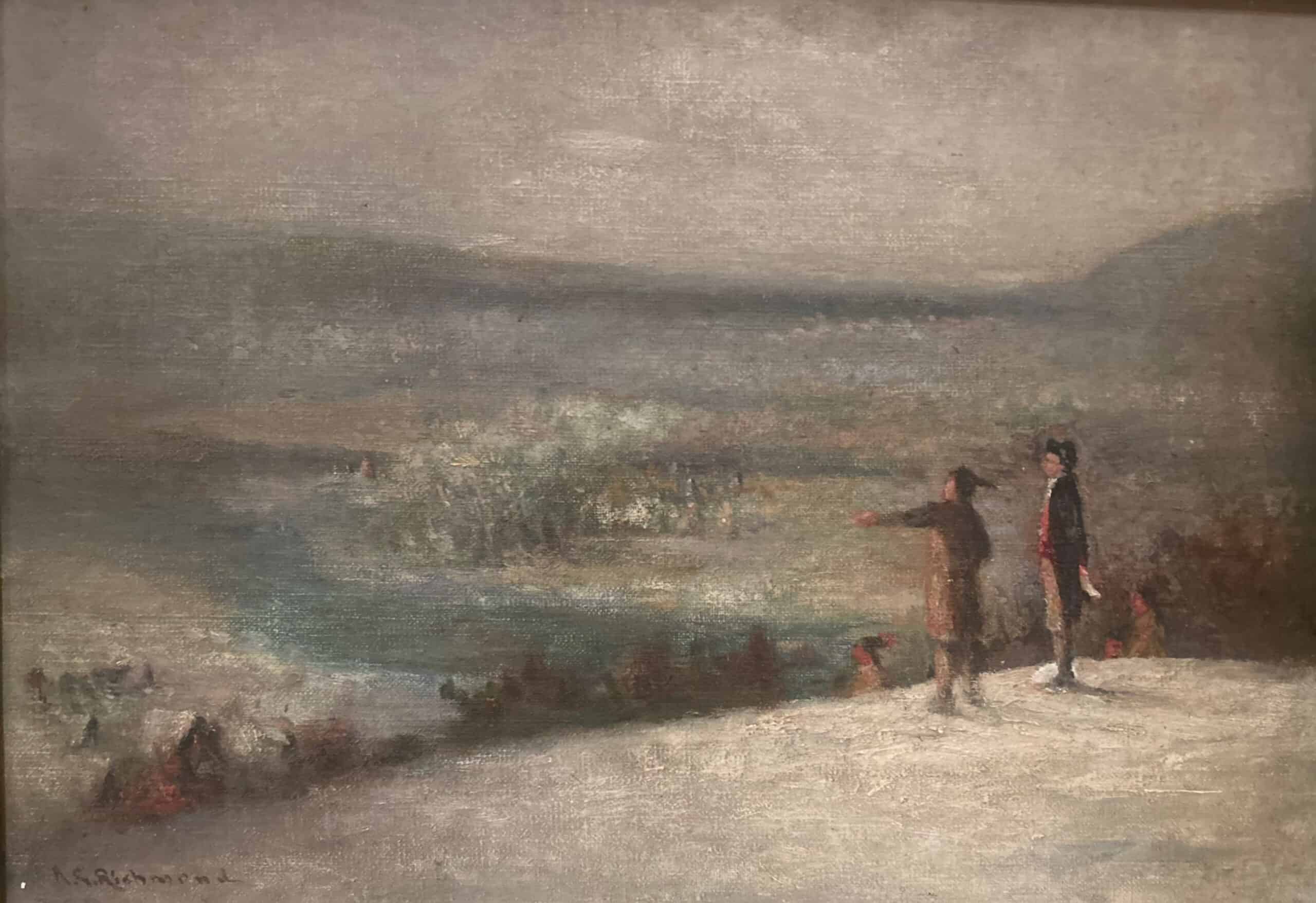
An express from Harrisburg, September 14, 1812, ordered Brigade Inspector Clark to call out his quota of 2,000 men from the counties west of the Allegheny Mountains, Pittsburgh, and Meadville. Instructions to accept companies of Pennsylvania volunteers were issued and ground for a camp in Meadville was offered by Samuel Lord. The camp extended east from Terrace Street to the present location of Allegheny College, including the property now inhabited by Mount Hope: The Baldwin-Reynolds House Museum. Inaction produced the usual depredations connected with camp life. Shortly before the troops departed for Erie, one man was court-martialed and drummed out of camp with a wreath of onions around his neck.
The command on Lake Erie was assigned to Lieutenant Oliver Hazard Perry who arrived in Erie in March, 1813. In July, six enemy vessels appeared outside the harbor. Perry dispatched a message to General Mead in Meadville for more troops and Mead published an appeal in the Crawford Weekly Messenger for men to defend their country. There was an immediate response by the citizens of Crawford County and large numbers of men left Meadville that same afternoon, marching all night to arrive in Erie the next morning. The news of Perry's victory was published in the Crawford Weekly Messenger on September 22, 1813. There was great relief and rejoicing throughout the county.
Banking and Finances
Allegheny College
Canals and Turnpikes
The Commonwealth encouraged canals and toll roads through the Legislature, authorizing the incorporation of companies to build them, and by liberal appropriations to assist in construction and upkeep, just as it does today for roads and schools.
French Creek flows through Crawford County from north to south. It was the chief means of shipping local lumber and New York State salt to the market in Pittsburgh. Thousands of barrels of salt loaded on arks or keel boats passed through the county when the water was at flood stage. The only other means of transportation in those days was by horses and wagons. The answer to the crying need for better transportation seemed at hand in 1826. Major Douglass suggested forcing the waters of French Creek to raise the water level of Conneaut Lake. The French Creek Feeder of the Beaver and Erie Canal would raise the lake eleven feet to assure a sufficient depth to get canal boats over the summit and north to Erie. The Conneaut Lake reservoir, when full, was 510 feet above Lake Erie and in the forty miles between them there were 72 locks. The Beaver and Erie Canal crossed the western part of Crawford County from north to south and was the first transportation route constructed by man, other than turnpike toll roads, in the county.
The following August when word spread that the Feeder Canal would be built, the citizens of Meadville planned a celebration for the breaking ground. On Monday, August 27, 1827, the people assembled in Diamond Park and formed a procession. They marched down Chestnut Street, up Water Street, then north on the French Creek Road (Terrace Street) to a point opposite Tanner White's house. After a prayer by Reverend T. Alden and an oration by Henry Baldwin, Jr., Robert Fitz Randolph and Cornelius Van Horne "broke ground." Again the procession formed and proceeded to Lord's spring where they partook of a cold collation and stove in a barrel of whiskey. The procession then returned to Diamond Park where it disbanded in high spirits.
The French Creek Feeder, which obtained its water from French Creek at Bemus' Mills, followed the east bank of the creek south to Meadville and at the north end of Water Street took a south easterly course through the town, crossing Chestnut Street at a point between Market Street and Park Avenue. Below Meadville it paralleled the Cochranton Road (now Route 322) for over six miles to Shaws Landing before turning west to cross French Creek at the aqueduct and then continuing on to Conneaut Lake. The Feeder Canal was approximately 22 miles long. Raising the level of Conneaut Lake necessitated the overflowing of several hundred acres of land, which were condemned and damages paid by the State. The aqueduct over French Creek was completed in 1830. The Canal was completed in 1834 and canal boats began operating between Bemustown Dam and Conneaut Lake.
By 1843, a little more than 97 miles of the main canal had been built from Rochester to Conneaut Lake and 49 miles had been completed from Conneaut Lake to Erie. Four million dollars had been spent by the State, and it was estimated that $211,000 more would be required to complete the 39 miles necessary to reach Pittsburgh. Apparently the State had become tired of its undertaking and in 1843 the Legislature passed an Act incorporating the Erie Canal Company. It gave the company the canal at its then stage of completion. The Erie Canal Company completed the canal and navigation was officially opened in 1845. It was profitable for more than twenty years until railroad competition arose. The canal was abandoned in 1872.
In 1876, all the property of the Erie Canal Company was sold at Sheriff's sale. Conneaut Lake was lowered to its natural level, and the property around it, which had been overflowed, became vested in the Conneaut Lake Ice Company. The company engaged in the cutting and storage of natural ice for distribution during the ensuing summers to towns and cities over a wide area. The Ice Company originally claimed the title to the lake, as well as the overflowed land surrounding it on the theory that it had been owned by the Canal Company whose title had vested in the Ice Company. It was not until 1906 that the courts adjudicated that Conneaut Lake was a navigable body of water and was public property owned by the Commonwealth. The Commonwealth of Pennsylvania assumed jurisdiction and control and has established the legal level of the lake at 1,073 feet above sea level, its original level.
The Meadville-Waterford-Erie Turnpike, constructed 1806 - 1809, was a useful avenue of commerce for thirty-five years, until it was abandoned to the townships it traversed. The road became a part of the Susquehanna and Waterford Turnpike, which was authorized in 1812 and built 1818-1824. It extended from the Susquehanna River in Clearfield County through Brookville, Clarion, Franklin, and Meadville to Erie. Toll gates were located every five to ten miles along its course. It was abandoned in 1845.
The Mercer and Meadville Turnpike Company was incorporated in 1817 and the road completed in 1821. It is still known to county residents as the Mercer Pike. It leaves Meadville over the Mercer Street bridge, through Kerrtown, over Kennedy Hill, and southward to Sheakleyville where the Perry Highway (Route 19) enters and follows it straight to Mercer.
Discovering Oil
Railroads
The lack of adequate shipping facilities had always been a problem in the development of manufacturing and the sending of county produce to outside markets. There was great excitement when the Atlantic and Great Western Railway of Pennsylvania was completed into Meadville in October 1862. With Meadville practically half way between New York and Chicago, the railroad opened a wide area of markets to Crawford County. The project of a railroad took active form in 1850 but it was not until some years later and principally through the efforts of William Reynolds, John Dick, Gaylord Church, and James J. Shryock, that it was accomplished. Constructed during the Civil War years, financing such an undertaking met with many obstacles and opposition at home. It was finally accomplished through aid from Europe. The steel rails for the railroad were shipped from England. William Reynolds’ accounts of the railroad’s creation are published and for sale at the Historical Society.
The Pittsburgh and Erie Railroad was completed thru Linesville to Conneautville in 1864. A railroad from Corry through Titusville to Oil City transversed the eastern end of Crawford County. It was completed in 1862, early in the oil industry's history. The Meadville and Linesville Railroad, built entirely with local capital, was constructed in 1881. Later it was leased by and became a part of the Bessemer and Lake Erie Railroad. The Pittsburgh, Shenango, and Lake Erie Railroad extended its lines through Crawford County to Conneaut, Ohio, in 1892, largely built on the towpath of the old Erie Canal. Today these railroads are part of the Norfolk Southern Railway and the Western New York and Pennsylvania Railroad.
Direct Primary Elections
Industry, Agriculture, and a Growing County
Tourism, Recreation, and Outdoor Development
The business stability of the county is materially reinforced by thriving resorts. The fine recreational facilities provided by Conneaut Lake, the Pymatuning Reservoir, Cambridge Springs, and Canadohta Lake attract thousands of summer visitors. The woods and streams of the entire county furnish good hunting and fishing to the natives as well as the tourists. The addition of a four-lane highway, Interstate 79, in the early 1970's has made Crawford County easily accessible.
The geography of the western part of Crawford County experienced a substantial change as the result of an Act of Assembly passed in 1913. It initiated the construction and development of the Pymatuning Reservoir and resulted in the development of a lake between Pennsylvania and Ohio with a shore line of 71 miles. It has secured the highly industrialized Shenango Valley in Mercer and Lawrence counties with an adequate supply of water year round. The reservoir and the Pymatuning Dam, which regulates the flow of water, was completed in 1935.
Townships, Villages, Boroughs, and Cities
Crawford County, which is one of the largest counties territorially in the Commonwealth of Pennsylvania, consists of two third-class cities, fourteen boroughs, and thirty-five second-class townships. The latter municipalities have interesting names which may be divided into three general categories. First there are the Greek classics such as Athens, Rome, Sparta, Steuben, and Troy; next there is a group of townships to which Indian names were given such as Conneaut, Cussewago, Shenango, and Venango. The third class were given English names, sometimes named after early settlers and sometimes in connection with some attribute of the landscape. This group includes Beaver, Bloomfield, Cambridge, Fairfield, Fallowfield, Greenwood, Hayfield, Mead (later divided into East and West Mead), Oil Creek, Pine, Randolph, Richmond, Rockdale, Sadsbury, Spring, Summerhill, Summit, Union, Vernon, Wayne, and Woodcock. Scattered through the county are fourteen thriving boroughs which have generally kept pace with the overall growth of the county. The names of the boroughs are: Blooming Valley, Cambridge Springs, Centerville, Cochranton, Conneaut Lake, Conneautville, Hydetown, Linesville, Saegertown, Spartansburg, Springboro, Townville, Venango, and Woodcock.
As of November 2000, the total assessed value of real estate lying within the county is $1,075,015,910.00 and the assessed value of non-taxable, religious, charitable, and educational properties is $297,281,529.00.
The clear streams and rich meadows which impressed Washington in 1753 still attract the attention of those who visit Northwestern Pennsylvania. The landscape is now dotted with myriads of homes, factories, churches and schools, connected by a modern network of highways indicating a thriving, prosperous, and progressive county.
Originally published as part of the program booklet dedicating the “new” Crawford County Courthouse in 1954. Used with permission by the Crawford County Commissioners, 2025. Edited for accuracy and clarity by the Crawford County Historical Society, 2025.